ASKTERRA – Terms and Conditions
Effective Date: September 18, 2025 Last Updated: September 18, 2025
Welcome to ASKTERRA ("App"), a software as a service (SAAS) developed by RedCastle Resources ("we," "our," or "us"). These Terms and Conditions ("Terms") govern your use of the App and its services. By accessing, purchasing, or using the App, you acknowledge that you have read, understood, and agreed to be bound by these Terms.
1. Eligibility and Account
To use the App, you must: - Be at least 18 years old; - Create an account as required; - Agree to comply fully with these Terms.
We reserve the right to approve or deny account creation and to suspend or terminate accounts at our sole discretion at any time and for any reason.
2. License Grant and Restrictions
Subject to your compliance with these Terms, you are granted a limited, revocable, non-exclusive, non-sublicensable, and non-transferable license to access and use the App for its intended purpose.
You agree not to: - Reverse engineer, decompile, or disassemble any part of the App; - Use the App for any unlawful, harmful, or unauthorized purpose; - Copy, distribute, or disclose any part of the App or its related materials;
3. Data Collection and Privacy
By using the App, you acknowledge and consent to the collection and processing of data, including: - Your username and interactions with the App; - Performance data and usage patterns.
This data is used to improve the App and conduct internal research. All personal data will be handled in accordance with our Privacy Policy, which is incorporated by reference.
4. Feedback
Any feedback, suggestions, ideas, or bug reports you submit are welcomed and appreciated. By providing feedback, you grant RedCastle Resources a royalty-free, worldwide, perpetual, irrevocable license to use, modify, incorporate, and distribute your feedback in any way we choose, without compensation or acknowledgment.
5. No Warranties
You acknowledge that the App is provided "as is" and "as available." We make no warranties—express, implied, or statutory—including but not limited to fitness for a particular purpose, reliability, accuracy, or performance. Use is at your own risk.
6. Limitation of Liability
To the maximum extent permitted by law: - RedCastle Resources shall not be liable for any indirect, incidental, consequential, or special damages arising from your use of the App; - Your sole remedy for dissatisfaction with the App is to discontinue use.
7. Termination
We may, at any time and for any reason: - Modify or terminate the App or its services with or without notice; - Revoke or suspend your account and access to the App, particularly if you violate these Terms or your subscription has expired.
Upon termination, you must cease all use of the App.
8. Governing Law
These Terms shall be governed by and construed under the laws of Utah state, without regard to conflict of laws principles. Any disputes shall be exclusively resolved in the courts located in Utah.
9. Contact
For any questions or support, please contact us at:
Email: [email protected]
10. Acknowledgment and Acceptance
By creating an account or using the ASKTERRA App, you confirm: - You have read and understood these Terms; - You agree to abide by all requirements herein.
Welcome to ASKTERRA
AI-Powered Earth Observation Made Simple
Chat with AI to instantly generate maps and analyze satellite imagery worldwide. No coding or GIS expertise required.
What is ASKTERRA?
ASKTERRA is a conversational AI platform that makes satellite imagery analysis accessible to everyone. Simply type your questions in plain text, and our AI will generate maps, detect changes, and forecast environmental conditions—all through an intuitive chat interface.
How It Works
1. Ask Your Question
Type your question in plain text about any location on Earth. No technical knowledge needed.
2. AskTerra Analyzes Your Question
Our AI processes your question and generates a map based on the data available.
3. Get Instant Maps
Receive interactive maps showing environmental conditions, changes, and forecasts.
4. Export & Share
Download your results as GeoTIFFs, PDF reports, map services, or share your entire conversation and findings with others.
What You Can Do with ASKTERRA
Monitor Environmental Changes
Track deforestation, urban growth, water levels, vegetation health, and land use changes over time with advanced change detection algorithms.
Assess Disaster Impacts
Analyze floods, wildfires, hurricanes, and other natural disasters to support emergency response and recovery efforts.
Forecast Weather & Risk
Access AI-powered weather forecasts from Google DeepMind's WeatherNext and predict potential tree damage from wind events.
Study Ecosystems
Examine vegetation patterns, habitat changes, and environmental conditions for conservation and research.
See ASKTERRA in Action
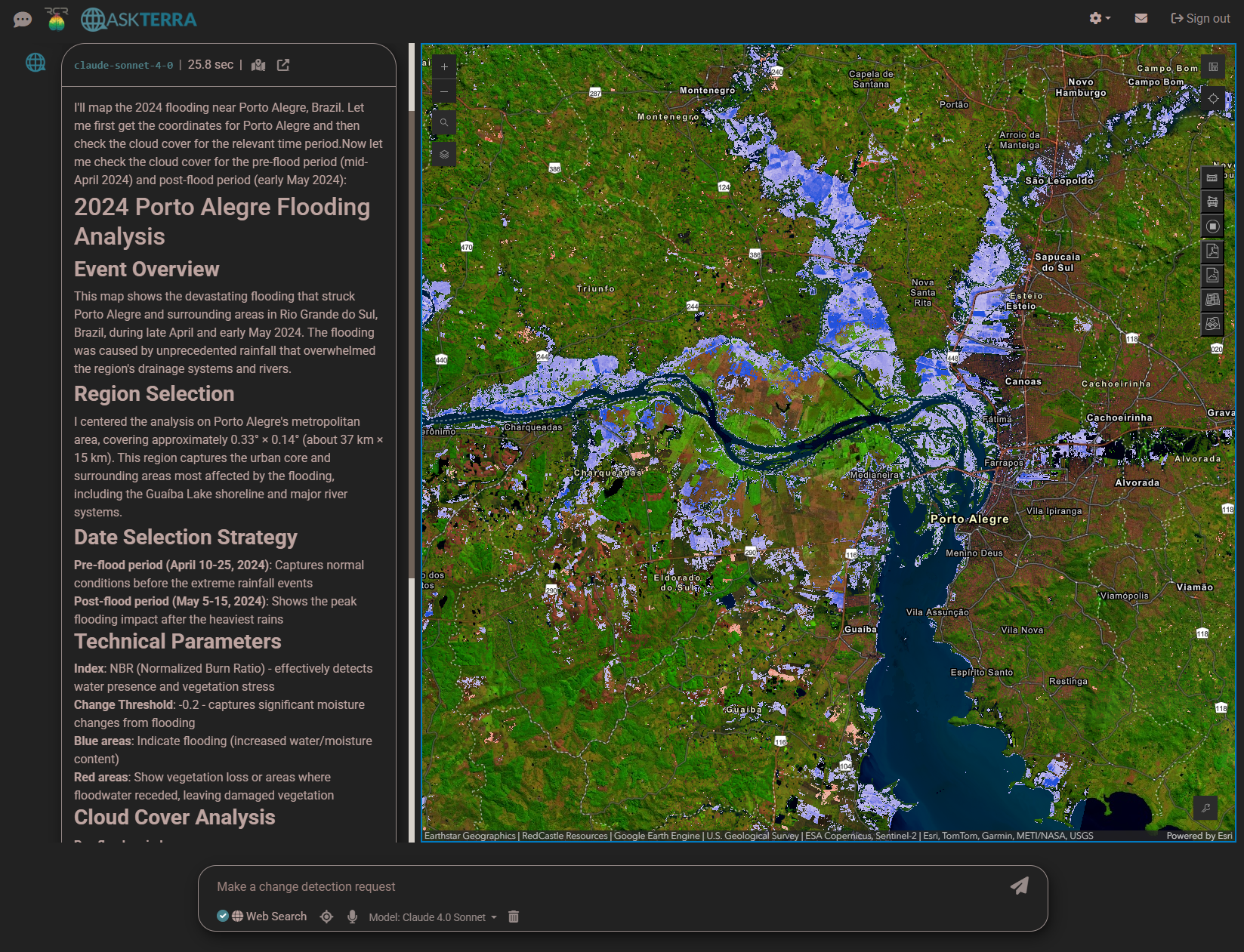
Porto Alegre Flooding (May 2024)
When severe flooding hit Porto Alegre, Brazil, ASKTERRA used Sentinel-2 satellite data to quickly map the flooded areas. The dark regions show submerged zones, helping emergency responders coordinate rescue operations and assess infrastructure damage.
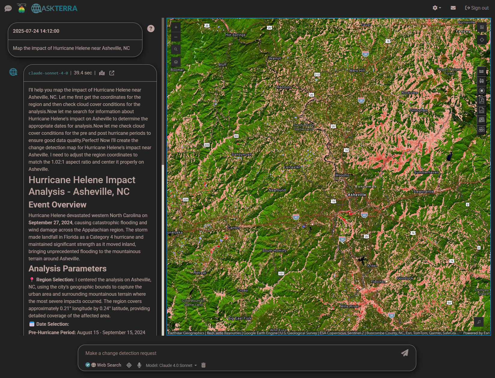
Hurricane Helene Impact (2024)
ASKTERRA tracked Hurricane Helene's path and its devastating impact on Asheville, NC. By analyzing before-and-after satellite imagery, users could identify affected areas and support recovery planning.
Who Uses ASKTERRA?
Educators & Researchers
Perfect for teaching environmental science and conducting geospatial research without complex GIS software.
Journalists
Quickly visualize and report on environmental changes, disasters, and land use trends with up-to-date satellite imagery.
Policy Makers
Access real-time environmental data to inform decision-making processes and policy development.
Conservation Groups
Monitor deforestation, track habitat changes, and support conservation efforts worldwide.
Our Mission: Earth Observation AI for Everyone
In recent years, powerful satellite imagery and earth observation tools have become more available than ever. From NASA's Landsat archives to the European Space Agency's Sentinel missions, terabytes of environmental data are collected every day. Cloud platforms like Google Earth Engine make it possible to process this data at planetary scale.
Yet for most people, accessing these resources remains out of reach. Traditional GIS software requires specialized training. Programming skills are often necessary. Complex workflows create barriers to entry.
ASKTERRA changes this. By combining cutting-edge AI language models with Google Earth Engine's processing power, we've created a platform where anyone can explore and analyze earth observation data through simple conversations. Just type your question—our AI handles the rest.
Whether you're a student learning about climate change, a journalist investigating environmental stories, or a conservationist tracking habitat loss, ASKTERRA makes powerful geospatial analysis accessible to you.
The Technology Behind ASKTERRA
Data Sources
- Landsat - 50+ years of Earth imagery from NASA/USGS
- Sentinel-2 - High-resolution imagery from the European Space Agency
- WeatherNext - AI weather forecasts from Google DeepMind
Processing Power
- Google Earth Engine - Planetary-scale geospatial analysis
- geeViz - Advanced algorithms for change detection and compositing
AI Language Models
Our platform currently uses Perplexity (Sonar) as the AI language model behind ASKTERRA. We chose Perplexity because it delivers high-quality responses quickly and, uniquely, cites trustworthy sources in its answers. This ensures that the information you receive is both relevant and reliable.
ASKTERRA is designed to be adaptable, and in the future we may integrate other state-of-the-art models such as OpenAI's ChatGPT, Anthropic's Claude, Google's Gemini, or XAI's Grok. For now, Perplexity enables us to provide fast, accurate, and well-sourced geospatial insights for your questions.
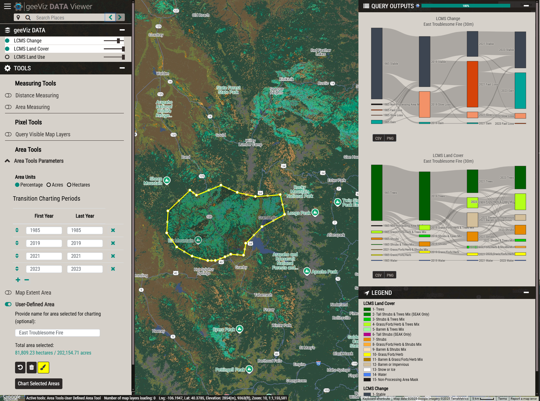
geeViz provides powerful area charting and analysis capabilities
Built by Experts in Geospatial Science
RedCastle Resources
ASKTERRA is developed by RedCastle Resources, a small business specializing in natural resource and environmental applications of geospatial data. With over 25 years of experience, we provide innovative solutions for geospatial data science, visualization, and cloud computing.
Our team has worked with government agencies, research institutions, and conservation organizations worldwide to deliver cutting-edge geospatial solutions.
Get Started with ASKTERRA
Sign up and discover how easy it is to analyze satellite imagery and environmental change using AskTerra.
Sign In / Sign Up Learn more in our Help & FAQ